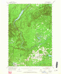
1954 Map of Sidnaw
USGS Topo · Published 1965About this map
The Sturgeon River carves a deep path through the north-central woods of the Upper Peninsula, its flow managed by the Prickett Dam which created Prickett Lake at the border of Houghton and Baraga counties. This mid-century landscape is defined by the logging and transit corridors of the Duluth South Shore and Atlantic and the C M ST P & P railroads. These lines connect the small rail-aligned settlements of Sidnaw, Watton, and Covington, the latter of which serves as a local hub for the surrounding timberlands of the Baraga State Forest.
Find a feature on this map
47 named features on this map. Tap any name to fly to it.
Don’t see what you’re looking for? This feature index may not catch every label — zoom into the map to look around manually.
Map Details
Editions of this 1954 Sidnaw Map
2 editions found
Other maps of this area

1895 · Ned Lake
USGS Topo · 1:62,500

1895 · Perch Lake
USGS Topo · 1:62,500

1954 · Rousseau
USGS Topo · 1:62,500

1954 · Kenton
USGS Topo · 1:62,500

1954 · Keweenaw Bay
USGS Topo · 1:62,500

1954 · Perch Lake
USGS Topo · 1:62,500

1954 · Pelkie
USGS Topo · 1:62,500

1954 · Winona
USGS Topo · 1:62,500

1954 · Sidnaw
USGS Topo · 1:62,500

1955 · Ned Lake
USGS Topo · 1:62,500