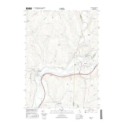
2016 Map of Sidney
USGS Topo · Published 2016About this map
The Susquehanna River winds through this tri-county region, serving as a primary corridor for both transportation and settlement. The village of Sidney sits at a strategic bend in the river, where the Unadilla River joins from the north. This geography established the area as a significant junction point for Chenango, Otsego, and Delaware Counties. The landscape is characterized by high ridges such as Sidney Mtn and Dingman Hill, which frame narrow valleys like Rogers Hollow.
Find a feature on this map
105 named features on this map. Tap any name to fly to it.
Don’t see what you’re looking for? This feature index may not catch every label — zoom into the map to look around manually.
Map Details
Editions of this 2016 Sidney Map
This is the sole edition of this map. No revisions or reprints were ever made.
Other maps of this area

1902 · Coventry
USGS Topo · 1:62,500

1904 · Oxford
USGS Topo · 1:62,500

1905 · Nineveh
USGS Topo · 1:62,500

1915 · Unadilla
USGS Topo · 1:62,500

1918 · Unadilla
USGS Topo · 1:62,500

1924 · Deposit
USGS Topo · 1:62,500

1926 · Deposit
USGS Topo · 1:62,500

1943 · Sidney
USGS Topo · 1:24,000

1943 · Gilbertsville
USGS Topo · 1:24,000
1943 · Unadilla
USGS Topo · 1:24,000