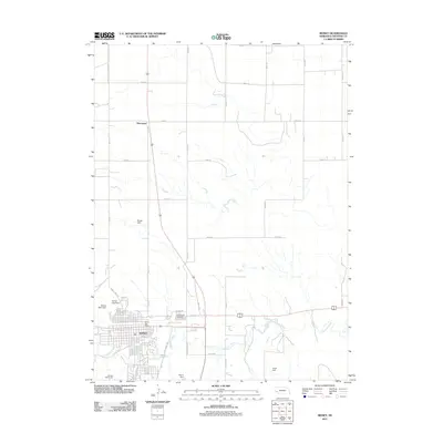
2011 Map of Sidney
USGS Topo · Published 2011About this map
Sidney and the surrounding plains of Cheyenne County are documented here during a period of modern expansion. The landscape is defined by the winding course of Lodgepole Creek, which flows through the southern portion of the city. A network of dams regulates the local waters, including the Sidney East Dam, Sidney West Dam, and Blanke Dam, illustrating the sophisticated water management required in this high-plains environment. The map details the transition from the structured residential grid of the town center to the expansive agricultural sections to the north, notably near the settlement of Huntsman.
Find a feature on this map
34 named features on this map. Tap any name to fly to it.
Don’t see what you’re looking for? This feature index may not catch every label — zoom into the map to look around manually.
Map Details
Editions of this 2011 Sidney Map
This is the sole edition of this map. No revisions or reprints were ever made.
Other maps of this area

1899 · Sidney
USGS Topo · 1:125,000

1954 · Scottsbluff
USGS Topo · 1:250,000

1958 · Scottsbluff
USGS Topo · 1:250,000

1972 · Gurley
USGS Topo · 1:24,000

1972 · Lorenzo
USGS Topo · 1:24,000

1972 · Brownson
USGS Topo · 1:24,000

1972 · Mud Springs SE
USGS Topo · 1:24,000

1972 · Sunol
USGS Topo · 1:24,000
1972 · Dalton SE
USGS Topo · 1:24,000
1972 · Sidney Muni. Airport
USGS Topo · 1:24,000