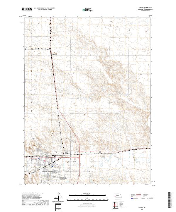
2021 Map of Sidney
USGS Topo · Published 2021About this map
The High Plains city of Sidney serves as the focal point of this Cheyenne County survey, revealing the organized grid of a vital Western Nebraska hub. The city's civic core is anchored by the Cheyenne County Courthouse, surrounded by established residential streets such as Elm St and Illinois St. Educational and community development is evident at the Western Nebraska Community College Sidney Campus on the city's southern edge. The landscape is defined by the valley of Lodgepole Cr, which cuts through the terrain north of the city, supported by water management features like Ruther Reservoir and Peetz Reservoir. To the north, the small settlement of Huntsman sits at a rural crossroads, while the sprawling Greenwood Cem marks the transition between the urban center and the surrounding agricultural sections.
Find a feature on this map
63 named features on this map. Tap any name to fly to it.
Don’t see what you’re looking for? This feature index may not catch every label — zoom into the map to look around manually.
Map Details
Editions of this 2021 Sidney Map
This is the sole edition of this map. No revisions or reprints were ever made.
Other maps of this area

1899 · Sidney
USGS Topo · 1:125,000

1954 · Scottsbluff
USGS Topo · 1:250,000

1958 · Scottsbluff
USGS Topo · 1:250,000

1972 · Gurley
USGS Topo · 1:24,000

1972 · Lorenzo
USGS Topo · 1:24,000

1972 · Brownson
USGS Topo · 1:24,000

1972 · Mud Springs SE
USGS Topo · 1:24,000

1972 · Sunol
USGS Topo · 1:24,000
1972 · Dalton SE
USGS Topo · 1:24,000
1972 · Sidney Muni. Airport
USGS Topo · 1:24,000