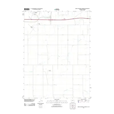
2011 Map of Sidney Municipal Airport
USGS Topo · Published 2011About this map
Sidney and its surrounding prairie landscape are defined by a geometric grid of rural roads and the vital transit corridors of the western plains. The northern edge of the map shows the transition from the city’s residential streets like Fort Sidney Rd to the open agricultural lands of Cheyenne County. Evidence of the region’s water management is visible in the placement of Verde Lane Dam and Ruther Dam, which control drainage across the high plains. The map illustrates the specialized infrastructure required for this region’s economy and travel, including the Sidney Municipal Airport and the smaller Fehringer Aerodrome to the south. Along the southern drainage, Cow Creek and Cottonwood Creek meander through the landscape, offering a natural contrast to the rigid section lines of the surrounding road network. Local heritage is marked by the presence of Grand Prairie Cemetery, a focal point for genealogical research in this part of Nebraska.
Find a feature on this map
32 named features on this map. Tap any name to fly to it.
Don’t see what you’re looking for? This feature index may not catch every label — zoom into the map to look around manually.
Map Details
Editions of this 2011 Sidney Municipal Airport Map
This is the sole edition of this map. No revisions or reprints were ever made.
Other maps of this area

1899 · Sidney
USGS Topo · 1:125,000

1953 · Peetz
USGS Topo · 1:24,000

1953 · Twin Buttes
USGS Topo · 1:24,000

1953 · Haystack Butte
USGS Topo · 1:24,000

1954 · Sterling
USGS Topo · 1:250,000

1954 · Scottsbluff
USGS Topo · 1:250,000

1958 · Scottsbluff
USGS Topo · 1:250,000

1958 · Sterling
USGS Topo · 1:250,000
1971 · Twin Buttes
USGS Topo · 1:24,000

1972 · Lorenzo
USGS Topo · 1:24,000