
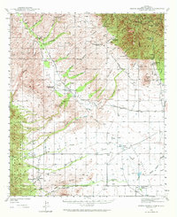
1940 Map of Sierra Bonita Ranch
USGS Topo · Published 1960About this map
Sierra Bonita Ranch and Eureka Ranch (Headquarters) anchor this high-desert landscape in Graham County, where the 1940 survey reveals a complex network of cattle ranching and water management. The terrain is defined by the Galiuro Mountains to the west and the southern edge of the Coronado National Forest to the north, with the drainage of Aravaipa Creek cutting through the canyons. Notable for local history, the map identifies specific family-named landmarks and infrastructure of the era, including the Sunset School, the Kennedy Cem, and a Landing Field near Eureka.
Find a feature on this map
65 named features on this map. Tap any name to fly to it.
Don’t see what you’re looking for? This feature index may not catch every label — zoom into the map to look around manually.
Map Details
Editions of this 1940 Sierra Bonita Ranch Map
2 editions found
Other maps of this area

1922 · Willcox
USGS Topo · 1:125,000

1938 · Galiuro Mts
USGS Topo · 1:48,000

1938 · Klondyke
USGS Topo · 1:48,000

1942 · Sierra Bonita Ranch
USGS Topo · 1:62,500

1942 · Mt. Graham
USGS Topo · 1:62,500

1943 · Willcox
USGS Topo · 1:62,500

1943 · Galiuro Mts
USGS Topo · 1:62,500

1943 · Klondyke
USGS Topo · 1:62,500

1943 · Sierra Bonita Ranch
USGS Topo · 1:62,500

1943 · Winchester Mts.
USGS Topo · 1:62,500