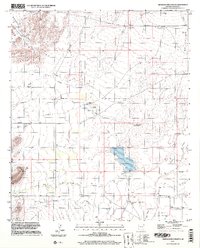
1996 Map of Sierra Bonita Ranch
USGS Topo · Published 2002About this map
Sierra Bonita Ranch serves as the focal point of this arid Graham County landscape, reflecting the long-standing ranching traditions of the region. The topography is defined by the Black Hills to the west and the expansive drainage systems of Aravaipa Creek and High Creek. A significant hydrological feature is the Hooker Cienega, a desert marshland that historically supported livestock and wildlife in an otherwise dry environment. The prevalence of features such as High Lonesome Windmill, several Water Tanks, and the Sunset Loop road network suggests a landscape carefully managed for cattle operations. Further south, the terrain descends toward Horton Creek and Ash Creek, while the surveyor's mark at Sunset East Base provides a glimpse into the precise mapping efforts required to document these remote range lands in the late twentieth century.
Find a feature on this map
21 named features on this map. Tap any name to fly to it.
Don’t see what you’re looking for? This feature index may not catch every label — zoom into the map to look around manually.
Map Details
Editions of this 1996 Sierra Bonita Ranch Map
This is the sole edition of this map. No revisions or reprints were ever made.
Other maps of this area

1922 · Willcox
USGS Topo · 1:125,000

1940 · Sierra Bonita Ranch
USGS Topo · 1:62,500

1942 · Sierra Bonita Ranch
USGS Topo · 1:62,500

1942 · Mt. Graham
USGS Topo · 1:62,500

1943 · Willcox
USGS Topo · 1:62,500

1943 · Sierra Bonita Ranch
USGS Topo · 1:62,500

1943 · Winchester Mts.
USGS Topo · 1:62,500

1945 · Mt. Graham
USGS Topo · 1:62,500

1945 · Winchester Mts.
USGS Topo · 1:62,500

1954 · Silver City
USGS Topo · 1:250,000