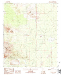
1989 Map of Silver Bell East
USGS Topo · Published 1989About this map
Mining operations and the physical remnants of the Silver Bell (Site) anchor this desert landscape at the end of the 1980s. The southwestern corner is dominated by industrial activity, including the expansive Oxide Pit, extensive Tailings, and numerous Adits and Prospects scattered across Portland Ridge. This industrial concentration contrasts sharply with the nearby Silver Bell Mountains and the prominent Ragged Top peak.
Find a feature on this map
23 named features on this map. Tap any name to fly to it.
Don’t see what you’re looking for? This feature index may not catch every label — zoom into the map to look around manually.
Map Details
Editions of this 1989 Silver Bell East Map
2 editions found
Other maps of this area

1934 · Tucson Mountains
USGS Topo · 1:125,000

1934 · Silver Bell
USGS Topo · 1:125,000

1934 · Newman Peak
USGS Topo · 1:125,000

1947 · Red Rock
USGS Topo · 1:62,500

1947 · Eloy
USGS Topo · 1:62,500

1948 · Eloy
USGS Topo · 1:62,500

1956 · Tucson
USGS Topo · 1:250,000

1958 · Tucson
USGS Topo · 1:250,000

1959 · Tucson
USGS Topo · 1:250,000

1959 · Vaca Hills
USGS Topo · 1:62,500