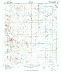
1959 Map of Silver Bell Peak
USGS Topo · Published 1982About this map
The Silver Bell Mountains dominate this 1959 landscape, where industrial mining and cattle ranching define the desert terrain northwest of Tucson. Heavy mineral extraction is evident at the Silver Bell settlement, flanked by a massive Tailings Pond and several workings including the Indiana-Arizona Mine and Silver Hill Mine. The eastern portion of the map transitions into the agricultural and transportation corridor of the Santa Cruz River valley, where the town of Marana sits near the junction of Hardin Road.
Find a feature on this map
57 named features on this map. Tap any name to fly to it.
Don’t see what you’re looking for? This feature index may not catch every label — zoom into the map to look around manually.
Map Details
Editions of this 1959 Silver Bell Peak Map
3 editions found
Other maps of this area

1925 · San Xavier
USGS Topo · 1:62,500

1934 · Tucson Mountains
USGS Topo · 1:125,000

1934 · Silver Bell
USGS Topo · 1:125,000

1934 · Newman Peak
USGS Topo · 1:125,000

1938 · San Vicente
USGS Topo · 1:62,500

1941 · San Vicente
USGS Topo · 1:62,500

1941 · Cocoraque Butte
USGS Topo · 1:62,500

1942 · San Vicente
USGS Topo · 1:62,500

1943 · Cocoraque Butte
USGS Topo · 1:62,500

1943 · San Xavier Mission
USGS Topo · 1:62,500