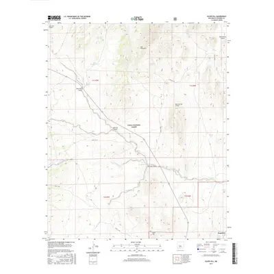
2017 Map of Silver Hill
USGS Topo · Published 2017About this map
Cibola National Forest encompasses much of this high-altitude landscape, where the northern reaches of Magdalena meet the rugged slopes of the Bear Mountains. The terrain is defined by a network of drainage features and seasonal water sources essential for life in the high desert, including Council Rock Arroyo and Arroyo Montosa. Cattle tanks and springs like Sand Tank, Threemile Spring, and Bear Springs are scattered throughout the quadrangle, illustrating the historical reliance on these specific points for ranching and survival. To the south, the namesake Silver Hill rises above the surrounding canyons. The path of Route 169 cuts through the center of the sheet, providing the primary access through Deep Well Canyon and across the La Jencia Cr drainage system, connecting the isolated mountain terrain to the settlement of Magdalena.
Find a feature on this map
28 named features on this map. Tap any name to fly to it.
Don’t see what you’re looking for? This feature index may not catch every label — zoom into the map to look around manually.
Map Details
Editions of this 2017 Silver Hill Map
This is the sole edition of this map. No revisions or reprints were ever made.
Other maps of this area

1954 · Socorro
USGS Topo · 1:250,000

1958 · Socorro
USGS Topo · 1:250,000

1959 · Magdalena
USGS Topo · 1:62,500

1959 · Riley
USGS Topo · 1:62,500

1962 · Socorro
USGS Topo · 1:250,000

1963 · Arroyo Landavaso
USGS Topo · 1:24,000

1964 · Silver Hill
USGS Topo · 1:24,000

1964 · Tres Montosas
USGS Topo · 1:24,000

1964 · Gallinas Peak
USGS Topo · 1:24,000
1964 · Mesa Cencerro
USGS Topo · 1:24,000