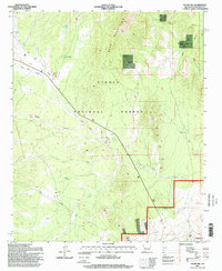
1995 Map of Silver Hill
USGS Topo · Published 1998About this map
The Bear Mountains define the high terrain of this portion of the Cibola National Forest, where isolated cattle operations and seasonal water sources shaped the ranching landscape of the late twentieth century. Dispersed across the territory are several named ranches including Threemile Ranch, Bear Spring Ranch, and Pueblito Ranch, each situated near critical water points like Threemile Spring and Bear Spring. The presence of Allen Well Corral and Dry Mill Corral indicates the importance of livestock management in this arid New Mexico environment. Further south, the landscape is marked by the namesake Silver Hill and the drainage of La Jencia Creek. The intricate network of canyons and arroyos, such as Deep Well Canyon and Council Rock Arroyo, suggests a terrain where topography dictated the routes of travel and the location of early range improvements. A telephone line crossing the lower reaches provides a trace of mid-century infrastructure connecting these remote outposts.
Find a feature on this map
32 named features on this map. Tap any name to fly to it.
Don’t see what you’re looking for? This feature index may not catch every label — zoom into the map to look around manually.
Map Details
Editions of this 1995 Silver Hill Map
This is the sole edition of this map. No revisions or reprints were ever made.
Other maps of this area

1954 · Socorro
USGS Topo · 1:250,000

1958 · Socorro
USGS Topo · 1:250,000

1959 · Magdalena
USGS Topo · 1:62,500

1959 · Riley
USGS Topo · 1:62,500

1962 · Socorro
USGS Topo · 1:250,000

1963 · Arroyo Landavaso
USGS Topo · 1:24,000

1964 · Silver Hill
USGS Topo · 1:24,000

1964 · Tres Montosas
USGS Topo · 1:24,000

1964 · Gallinas Peak
USGS Topo · 1:24,000
1964 · Mesa Cencerro
USGS Topo · 1:24,000