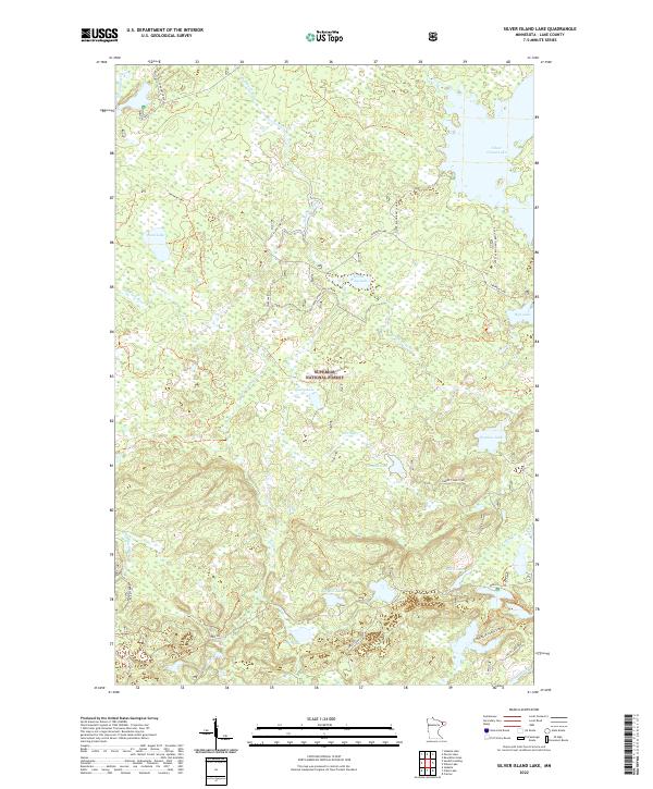
2022 Map of Silver Island Lake
USGS Topo · Published 2022About this map
Superior National Forest dominates this northern landscape, where a dense network of glacial lakes and watercourses defines the geography of Lake County. Large bodies of water like Silver Island Lake and Wanless Lake are connected by small streams such as Comfort Creek and the Dumbbell River. The map illustrates a region managed for both conservation and recreation, evidenced by the Silver Island Boat Landing and a web of forest service roads including Lake 29 East and Trappers Lake.
Find a feature on this map
36 named features on this map. Tap any name to fly to it.
Don’t see what you’re looking for? This feature index may not catch every label — zoom into the map to look around manually.
Map Details
Editions of this 2022 Silver Island Lake Map
This is the sole edition of this map. No revisions or reprints were ever made.
Other maps of this area

1954 · Two Harbors
USGS Topo · 1:250,000

1955 · Isabella
USGS Topo · 1:62,500

1955 · Cramer
USGS Topo · 1:62,500

1957 · Two Harbors
USGS Topo · 1:250,000

1958 · Two Harbors
USGS Topo · 1:250,000

1960 · Kawishiwi Lake
USGS Topo · 1:24,000

1960 · Perent Lake
USGS Topo · 1:24,000

1964 · Two Harbors
USGS Topo · 1:250,000
1981 · Silver Island Lake
USGS Topo · 1:24,000
1981 · Cramer
USGS Topo · 1:24,000