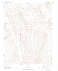
1971 Map of Silver King Mtn SW
USGS Topo · Published 1973About this map
White River flows southward through this high-altitude basin on the edge of the Dry Lake Valley, defining the geographic character of a territory shared by Nye and Lincoln counties. The landscape is marked by the scarce water resources typical of the Great Basin, including the Rye Patch Reservoir and the White River Well. A network of an unnamed Jeep Trail provides the only documented passage through the varied topography, suggesting a region utilized primarily for ranching or remote transit rather than permanent settlement. The proximity of the county line highlights the administrative divisions in this sparsely populated interior, where the river's path is the most prominent feature among the surrounding elevations.
Find a feature on this map
6 named features on this map. Tap any name to fly to it.
Don’t see what you’re looking for? This feature index may not catch every label — zoom into the map to look around manually.
Map Details
Editions of this 1971 Silver King Mtn SW Map
This is the sole edition of this map. No revisions or reprints were ever made.
Other maps of this area

1885 · Pioche
USGS Topo · 1:250,000

1886 · Pioche
USGS Topo · 1:250,000

1954 · Caliente
USGS Topo · 1:250,000

1956 · Lund
USGS Topo · 1:250,000

1959 · Caliente
USGS Topo · 1:250,000

1960 · Lund
USGS Topo · 1:250,000
1970 · Deadman Spring
USGS Topo · 1:24,000
1970 · Deadman Spring NE
USGS Topo · 1:24,000
1970 · Weepah Spring
USGS Topo · 1:24,000

1971 · Bailey Wash
USGS Topo · 1:24,000