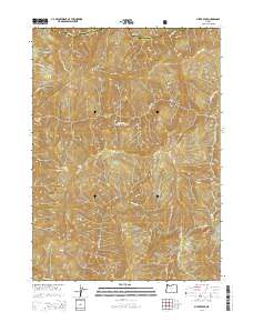
2014 Map of Silver Peak
USGS Topo · Published 2014About this map
Siskiyou National Forest land dominates this 2014 survey, highlighting the complex drainage patterns of the Illinois River as it passes through the southwestern corner of the quadrangle. Several high-elevation prairies, including Silver Prairie, Middle Bald Prairie, and Little Bald Mountain Prairie, sit between major peaks such as Silver Peak and Bald Mtn. The landscape is defined by the sharp convergence of multiple watercourses, where Indigo Cr, Silver Cr, and Sulphur Cr carve deep canyons before reaching the river. A notable river feature, Deadman Bar, is visible along the Illinois River, reflecting local landforms within this protected forest. While primary human infrastructure is limited to Nat For Dev Rd 091, the map meticulously documents natural water sources like Polar Spring and smaller tributaries like Falcon Cr and Klondike Cr.
Find a feature on this map
29 named features on this map. Tap any name to fly to it.
Don’t see what you’re looking for? This feature index may not catch every label — zoom into the map to look around manually.
Map Details
Editions of this 2014 Silver Peak Map
This is the sole edition of this map. No revisions or reprints were ever made.
Other maps of this area

1899 · Port Orford
USGS Topo · 1:125,000

1903 · Port Orford
USGS Topo · 1:125,000

1917 · Kerby
USGS Topo · 1:125,000

1918 · Kerby
USGS Topo · 1:125,000

1945 · Kerby
USGS Topo · 1:125,000

1954 · Coos Bay
USGS Topo · 1:250,000

1954 · Marial
USGS Topo · 1:62,500

1954 · Collier Butte
USGS Topo · 1:62,500

1954 · Agness
USGS Topo · 1:62,500

1954 · Pearsoll Peak
USGS Topo · 1:62,500