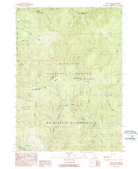
1989 Map of Silver Peak
USGS Topo · Published 1989About this map
Silver Peak and the high ridges of the Siskiyou National Forest dominate this late 20th-century survey along the border of Curry and Josephine counties. The landscape is defined by the sharp descent from peaks like Bald Mountain and South Bend Mountain toward the deep canyon of the Illinois Wild and Scenic River. This reach of the river includes notable riverfront features like Deadman Bar and the secluded Green Wall near the southern boundary.
Find a feature on this map
30 named features on this map. Tap any name to fly to it.
Don’t see what you’re looking for? This feature index may not catch every label — zoom into the map to look around manually.
Map Details
Editions of this 1989 Silver Peak Map
This is the sole edition of this map. No revisions or reprints were ever made.
Other maps of this area

1899 · Port Orford
USGS Topo · 1:125,000

1903 · Port Orford
USGS Topo · 1:125,000

1917 · Kerby
USGS Topo · 1:125,000

1918 · Kerby
USGS Topo · 1:125,000

1945 · Kerby
USGS Topo · 1:125,000

1954 · Coos Bay
USGS Topo · 1:250,000

1954 · Marial
USGS Topo · 1:62,500

1954 · Collier Butte
USGS Topo · 1:62,500

1954 · Agness
USGS Topo · 1:62,500

1954 · Pearsoll Peak
USGS Topo · 1:62,500