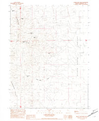
1982 Map of Silver State Draw
USGS Topo · Published 1982About this map
The Slumbering Hills dominate the western portion of this Great Basin landscape, where high-desert elevations meet the floor of the Silver State Valley. This 1982 provisional survey documents a network of vital water sources tucked into the mountain drainages, including Daveytown Spring and the sequentially numbered Circle Bar No 1, No 2, and No 3 springs. Human activity in this arid environment is centered on resource extraction and livestock watering, with the Silver State Mine and Silver State Spring marking the head of the Silver State Draw. To the north, Pickhandle Pass provides a named transit point through the range, while the southeastern corner reveals a shift in terrain toward shifting Sand Dunes. The map preserves the specific locations of these named springs and ranching-related landmarks before modern modifications altered the high-desert character.
Find a feature on this map
15 named features on this map. Tap any name to fly to it.
Don’t see what you’re looking for? This feature index may not catch every label — zoom into the map to look around manually.
Map Details
Editions of this 1982 Silver State Draw Map
This is the sole edition of this map. No revisions or reprints were ever made.
Other maps of this area

1882 · Paradise
USGS Topo · 1:250,000

1886 · Disaster
USGS Topo · 1:250,000

1893 · Paradise
USGS Topo · 1:250,000

1893 · Disaster
USGS Topo · 1:250,000

1954 · Vya
USGS Topo · 1:250,000

1955 · McDermitt
USGS Topo · 1:250,000

1958 · Vya
USGS Topo · 1:250,000

1958 · Awakening Peak
USGS Topo · 1:62,500

1959 · McDermitt
USGS Topo · 1:250,000

1962 · Vya
USGS Topo · 1:250,000