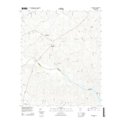
2014 Map of Silverstreet
USGS Topo · Published 2014About this map
Silverstreet and its rural surroundings in Newberry County and Saluda County are defined by the winding course of the Saluda River, which flows into the northwestern reaches of Lake Murray. This landscape preserves the traditional settlement patterns of the South Carolina Midlands, centered on junctions like Deadfall Crossroads and small communities such as Trinity and Higgins. The map serves as a valuable resource for genealogical research, documenting numerous rural burial sites including the Bush River Meetinghouse Cem, Shady Grove Cem, and Merchant Cem. Movement across the terrain is dictated by historical crossings and modern infrastructure, from the Higgins Bridge to the Kempsons Ferry Bridge near the lake. The interplay between agriculture and water resources is evident in the many small tributaries like Beaverdam Cr and Tosity Cr, alongside man-made features like W Colemans Pond.
Find a feature on this map
79 named features on this map. Tap any name to fly to it.
Don’t see what you’re looking for? This feature index may not catch every label — zoom into the map to look around manually.
Map Details
Editions of this 2014 Silverstreet Map
This is the sole edition of this map. No revisions or reprints were ever made.
Other maps of this area

1941 · Spartanburg
USGS Topo · 1:250,000

1953 · Spartanburg
USGS Topo · 1:250,000

1960 · Spartanburg
USGS Topo · 1:250,000

1963 · Spartanburg
USGS Topo · 1:250,000

1964 · Spartanburg
USGS Topo · 1:250,000

1968 · Newberry East
USGS Topo · 1:24,000

1969 · Newberry West
USGS Topo · 1:24,000
1970 · Prosperity
USGS Topo · 1:24,000
1970 · Bush River
USGS Topo · 1:24,000
1970 · Delmar
USGS Topo · 1:24,000