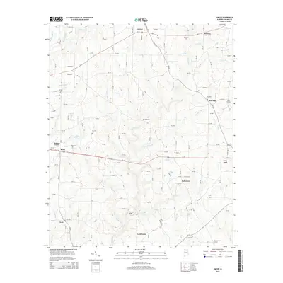
2014 Map of Simcoe
USGS Topo · Published 2014About this map
The Duck River and its numerous tributaries, including Indian Cr and Henderson Br, define the landscape of eastern Cullman County. This 2014 survey captures a region characterized by a high density of small rural communities and family burial grounds. The agricultural and residential layout of Holly Pond and Fairview is shown alongside smaller crossroads such as Berlin, Walkers Corner, and Simcoe. Genealogists will find considerable value in the documentation of local cemeteries like Oak Level Cem, Concord Cem, and Mt Vernon Cem. Infrastructure for the modern era is represented by the New Horizon Airport in the southeast corner, while older travel patterns are evidenced by landmarks like Tanner Bridge and Thornton Bridge crossing the river networks.
Find a feature on this map
165 named features on this map. Tap any name to fly to it.
Don’t see what you’re looking for? This feature index may not catch every label — zoom into the map to look around manually.
Map Details
Editions of this 2014 Simcoe Map
This is the sole edition of this map. No revisions or reprints were ever made.
Other maps of this area

1888 · Cullman
USGS Topo · 1:125,000

1892 · Cullman
USGS Topo · 1:125,000

1936 · Hulaco
USGS Topo · 1:24,000

1936 · Eva
USGS Topo · 1:24,000

1936 · Lawrence Cove
USGS Topo · 1:24,000

1936 · Holly Pond
USGS Topo · 1:24,000
1949 · Hulaco
USGS Topo · 1:24,000
1949 · Lawrence Cove
USGS Topo · 1:24,000
1949 · Eva
USGS Topo · 1:24,000
1951 · Lawrence Cove
USGS Topo · 1:24,000