
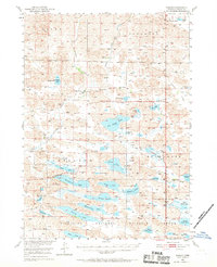
1950 Map of Simeon
USGS Topo · Published 1952About this map
The Valentine National Wildlife Refuge dominates the southern half of this landscape, encompassing a dense network of Sandhills lakes. Water bodies including Pelican Lake, Hackberry Lake, and Whitewater Lake characterize the hydrology of the Cherry County interior, while Gordon Creek and Schlagel Creek drain the northern reaches. The settlement of Simeon and the Simeon PO serve as the primary local hubs for a territory defined by isolated cattle operations. Numerous family-named homesteads such as Gordon Valley Ranch, Miller Ranch, and Lovejoy Ranch are noted across the quadrangle, reflecting the region's ranching economy during the mid-century. Educational and utility infrastructure is also recorded, featuring rural outposts like School No 20, Duck Lake Sch, and Lookout Tower No 1, which provides a vantage point over the expansive lake systems and surrounding Cleveland and Evergreen terrain.
Find a feature on this map
51 named features on this map. Tap any name to fly to it.
Don’t see what you’re looking for? This feature index may not catch every label — zoom into the map to look around manually.
Map Details
Editions of this 1950 Simeon Map
2 editions found
Other maps of this area

1949 · Long Lake
USGS Topo · 1:62,500

1950 · Sparks
USGS Topo · 1:62,500

1950 · Kennedy
USGS Topo · 1:62,500

1950 · Kilgore
USGS Topo · 1:62,500

1950 · Arabia
USGS Topo · 1:62,500

1950 · Valentine
USGS Topo · 1:62,500

1951 · Long Lake
USGS Topo · 1:62,500

1951 · Bull Lake
USGS Topo · 1:62,500

1951 · Brownlee
USGS Topo · 1:62,500

1957 · Valentine
USGS Topo · 1:250,000