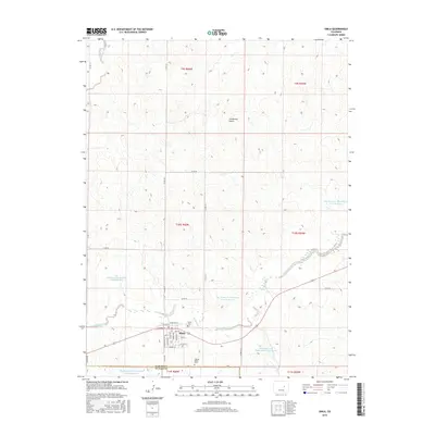
2016 Map of Simla
USGS Topo · Published 2016About this map
Simla serves as the primary hub for this high plains landscape at the transition between Elbert and El Paso counties. The town site is meticulously detailed with its original grid of streets, including Antelope St, Buffalo St, and Pueblo Ave. Water management is a defining characteristic of this terrain, evidenced by a series of regional impoundments such as the Big Sandy Cr Watershed N-21 Reservoir and Big Sandy Creek Watershed S-19 Reservoir along the winding course of Big Sandy Creek. For local historians and genealogists, the map preserves the location of the Simla Cem and the solitary Liptrap Single Grave located just south of the main settlement. Topographic features like Sixshooter Gulch further illustrate the drainage patterns that have shaped ranching and life in this part of eastern Colorado.
Find a feature on this map
41 named features on this map. Tap any name to fly to it.
Don’t see what you’re looking for? This feature index may not catch every label — zoom into the map to look around manually.
Map Details
Editions of this 2016 Simla Map
This is the sole edition of this map. No revisions or reprints were ever made.
Other maps of this area

1891 · Limon
USGS Topo · 1:125,000

1892 · Limon
USGS Topo · 1:125,000

1953 · Denver
USGS Topo · 1:250,000

1954 · Limon
USGS Topo · 1:250,000

1957 · Denver
USGS Topo · 1:250,000

1957 · Limon
USGS Topo · 1:250,000

1958 · Limon
USGS Topo · 1:250,000

1958 · Denver
USGS Topo · 1:250,000

1960 · Denver
USGS Topo · 1:250,000
1970 · Matheson SW
USGS Topo · 1:24,000