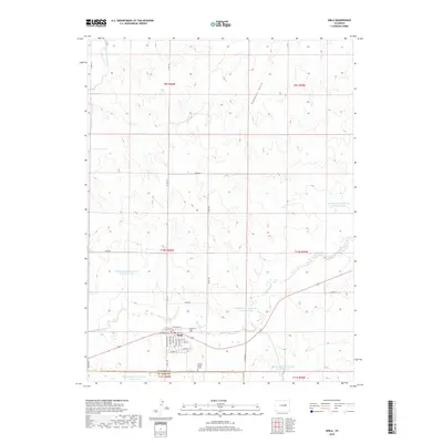
2019 Map of Simla
USGS Topo · Published 2019About this map
The town of Simla serves as the focal point of this Eastern Colorado landscape, situated along the border of Elbert and El Paso counties. The grid of the settlement is clearly defined by residential streets such as Washington Ave, Cheyenne Ave, and Buffalo ST, centered near the Simla Cem. This area is characterized by a significant water management infrastructure designed for the high plains environment, featuring numerous catchment points like the Big Sandy Cr Watershed N-21 Reservoir and the Big Sandy Cr Watershed S-16 Reservoir. Beyond the town limits, the terrain is marked by seasonal drainages including Sixshooter Gulch and Reed Springs Creek. A unique genealogical detail is found just south of the town line: the Liptrap Single Grave, a solitary landmark that points to the early homesteading history of the region.
Find a feature on this map
41 named features on this map. Tap any name to fly to it.
Don’t see what you’re looking for? This feature index may not catch every label — zoom into the map to look around manually.
Map Details
Editions of this 2019 Simla Map
This is the sole edition of this map. No revisions or reprints were ever made.
Other maps of this area

1891 · Limon
USGS Topo · 1:125,000

1892 · Limon
USGS Topo · 1:125,000

1953 · Denver
USGS Topo · 1:250,000

1954 · Limon
USGS Topo · 1:250,000

1957 · Denver
USGS Topo · 1:250,000

1957 · Limon
USGS Topo · 1:250,000

1958 · Limon
USGS Topo · 1:250,000

1958 · Denver
USGS Topo · 1:250,000

1960 · Denver
USGS Topo · 1:250,000
1970 · Matheson SW
USGS Topo · 1:24,000