
1947 Map of Simmons
USGS Topo · Published 1958About this map
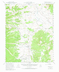
Simmons and the surrounding rangelands of the Chino Valley and Williamson Valley define this landscape within the Prescott National Forest. This 1940s-era survey documents a region characterized by expansive cattle operations and water management, visible through the numerous labeled windmills and ranch holdings like Las Vegas Ranch, Seven V Ranch, and Wineglass Ranch. The drainage systems, including Big Chino Wash and Williamson Valley Wash, illustrate the natural irrigation patterns critical to high-desert ranching. Local topography is anchored by prominent landmarks such as Simmons Pk and Sullivan Buttes. The infrastructure of the era is represented by the early telephone line traversing the valley and the placement of Antelope Dam, highlighting the transition from open range to more managed livestock production in central Arizona.
Find a feature on this map
31 named features on this map. Tap any name to fly to it.
Don’t see what you’re looking for? This feature index may not catch every label — zoom into the map to look around manually.
Map Details
Editions of this 1947 Simmons Map
2 editions found
Other maps of this area

1886 · Chino
USGS Topo · 1:250,000

1887 · Prescott
USGS Topo · 1:250,000

1891 · Chino
USGS Topo · 1:250,000

1892 · Prescott
USGS Topo · 1:250,000

1905 · Jerome
USGS Topo · 1:125,000

1922 · Williams
USGS Topo · 1:125,000

1947 · Ash Fork
USGS Topo · 1:62,500

1947 · Iron Springs
USGS Topo · 1:62,500

1947 · Picacho Butte
USGS Topo · 1:62,500

1947 · Paulden
USGS Topo · 1:62,500