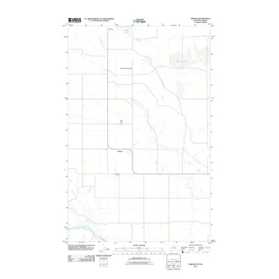
2011 Map of Simpson
USGS Topo · Published 2011About this map
Simpson lies in the northern reaches of Hill County, where the plains of Montana meet the Canadian border. This 2011 survey illustrates a sparse agricultural landscape defined by the drainage of Sage Creek and the southern flow of the Milk River. A sense of the region's historic connectivity is preserved in the path of the Old Wild Horse Trl, which cuts across the landscape toward the Port of Wild Horse. Local land use is centered around water management and memory, anchored by the New Calve Dam and the Spring Coulee Cemetery. The terrain is characterized by broad elevations like Spring Coulee Ridge and intermittent water bodies including Grassy Lake and the unusually named Wild Lake Lake. This map serves as a primary record of the northern borderlands, detailing the section lines and small-scale infrastructure that support this high-plains community.
Find a feature on this map
9 named features on this map. Tap any name to fly to it.
Don’t see what you’re looking for? This feature index may not catch every label — zoom into the map to look around manually.
Map Details
Editions of this 2011 Simpson Map
This is the sole edition of this map. No revisions or reprints were ever made.
Other maps of this area

1920 · Gildford
USGS Topo · 1:125,000

1943 · Gildford
USGS Topo · 1:125,000

1954 · Shelby
USGS Topo · 1:250,000

1958 · Shelby
USGS Topo · 1:250,000
1972 · Lost River NE
USGS Topo · 1:24,000
1972 · Wild Horse Lake West
USGS Topo · 1:24,000
1972 · Ninemile Coulee West
USGS Topo · 1:24,000
1972 · Ninemile Coulee East
USGS Topo · 1:24,000
1972 · St. Johns
USGS Topo · 1:24,000
1984 · Chester
USGS Topo · 1:100,000