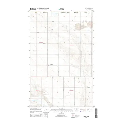
2014 Map of Simpson
USGS Topo · Published 2014About this map
Simpson serves as a central point in this high-plains landscape just south of the international border. The terrain is defined by dry lake beds and intermittent water sources, such as the northern Grassy Lake and the eastern Wild Horse Lake, which are situated among high-altitude plateaus. The Milk River enters the frame in the southwest corner, providing a vital riparian corridor in an otherwise arid environment. Along the route of MT-232, the Spring Coulee Cem and the nearby Spring Coulee Ridge offer specific points of interest for genealogists and local historians tracking the early homesteading patterns in Hill County. The grid-like arrangement of roads, including Road 290 N and Road 220 N, illustrates the enduring structure of the Public Land Survey System in this part of Montana.
Find a feature on this map
22 named features on this map. Tap any name to fly to it.
Don’t see what you’re looking for? This feature index may not catch every label — zoom into the map to look around manually.
Map Details
Editions of this 2014 Simpson Map
This is the sole edition of this map. No revisions or reprints were ever made.
Other maps of this area

1920 · Gildford
USGS Topo · 1:125,000

1943 · Gildford
USGS Topo · 1:125,000

1954 · Shelby
USGS Topo · 1:250,000

1958 · Shelby
USGS Topo · 1:250,000
1972 · Lost River NE
USGS Topo · 1:24,000
1972 · Wild Horse Lake West
USGS Topo · 1:24,000
1972 · Ninemile Coulee West
USGS Topo · 1:24,000
1972 · Ninemile Coulee East
USGS Topo · 1:24,000
1972 · St. Johns
USGS Topo · 1:24,000
1984 · Chester
USGS Topo · 1:100,000