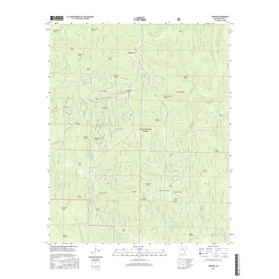
2017 Map of Simpson
USGS Topo · Published 2017About this map
Simpson and Tag anchor this portion of the Ozark National Forest, where the landscape is defined by the complex drainage systems of the North Fork Illinois Bayou and Moccasin Cr. The map reveals a deeply dissected terrain characterized by family-named landmarks and historical logging or milling locations, such as Stave Mill Hollow and Mose Freeman Hollow. A network of specialized forest roads, including the Gap Hollow Loop and High Mtn Loop B, wind through the ridges, providing access to secluded points like Mitchell Point and Bates Knob. The distribution of rural burial grounds, including Oak Grove Cem and Lane Cem, reflects the legacy of early settlements that persisted within these hollows long before the establishment of modern forest boundaries.
Find a feature on this map
71 named features on this map. Tap any name to fly to it.
Don’t see what you’re looking for? This feature index may not catch every label — zoom into the map to look around manually.
Map Details
Editions of this 2017 Simpson Map
This is the sole edition of this map. No revisions or reprints were ever made.
Other maps of this area

1879 · Washington
USGS Topo · 1:62,500

1887 · Smyrna
USGS Topo · 1:62,500

1888 · Dardanelle #1
USGS Topo · 1:62,500

1889 · Treat
USGS Topo · 1:62,500

1889 · Marshall #3
USGS Topo · 1:62,500

1890 · Dardanelle
USGS Topo · 1:125,000

1892 · Marshall
USGS Topo · 1:125,000

1892 · Morrillton
USGS Topo · 1:125,000

1894 · Morrillton
USGS Topo · 1:125,000

1894 · Marshall
USGS Topo · 1:125,000