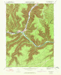
1945 Map of Sinnemahoning
USGS Topo · Published 1972About this map
Sinnemahoning Creek and its First Fork carve deep valleys through the heart of this Pennsylvania terrain, where the settlement of Sinnemahoning sits at the confluence. The landscape is defined by its industrial and transport infrastructure, featuring the Penn Central rail line tracing the water's edge and a long Pipeline cutting across the ridges. Small settlements like Driftwood, Jericho, and Wyside are tucked into the narrow gaps between steep slopes. Local history is preserved at the Miller Cem near the fork, while the remote character of the area is emphasized by the numerous named hollows and drafts, such as Pumpkin Hollow and Jerry Lick Draft. A Gaging Sta on the creek and a Grade following the lower runs suggest the active management of these waterways and forests during the mid-20th century.
Find a feature on this map
42 named features on this map. Tap any name to fly to it.
Don’t see what you’re looking for? This feature index may not catch every label — zoom into the map to look around manually.
Map Details
Editions of this 1945 Sinnemahoning Map
5 editions found
Other maps of this area

1928 · Snow Shoe
USGS Topo · 1:48,000

1929 · Karthaus
USGS Topo · 1:62,500

1931 · Show Shoe
USGS Topo · 1:62,500

1932 · Karthaus
USGS Topo · 1:62,500

1945 · Driftwood
USGS Topo · 1:48,000

1945 · First Fork
USGS Topo · 1:24,000

1945 · Sinnemahoning
USGS Topo · 1:24,000

1945 · Driftwood
USGS Topo · 1:24,000

1945 · Cameron
USGS Topo · 1:24,000

1946 · Renovo West
USGS Topo · 1:62,500
Featured Places
- West Keating Township, PA
- East Keating Township, PA
- Wyside, Grove Township
- Jericho, Grove Township
- Grove Township, PA