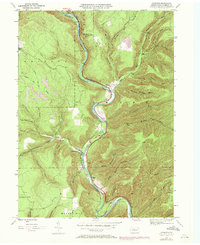
1945 Map of Cameron
USGS Topo · Published 1972About this map
Driftwood Branch Sinnemahoning Creek carves a deep valley through the high plateaus of Cameron County, serving as the primary corridor for both the Penn Central railroad and the region's early settlements. This mid-century survey captures the remote character of Shippen, Lumber, and Gibson townships, where small communities like Sterling Run and Cameron cling to the narrow valley floors. The landscape is defined by its drainage network, with countless hollows and runs such as Tannery Hollow Run and Stillhouse Run feeding into the main branch. Genealogists can identify several burial sites including Wylie Cem and Pine St Cem, while topographic landmarks like Huston Hill and Mason Hill illustrate the steep vertical relief that historically isolated these Pennsylvania mountain communities.
Find a feature on this map
40 named features on this map. Tap any name to fly to it.
Don’t see what you’re looking for? This feature index may not catch every label — zoom into the map to look around manually.
Map Details
Editions of this 1945 Cameron Map
3 editions found
Other maps of this area

1941 · Benezette
USGS Topo · 1:62,500

1943 · Benezette
USGS Topo · 1:62,500

1945 · Driftwood
USGS Topo · 1:48,000

1945 · First Fork
USGS Topo · 1:24,000

1945 · Sinnemahoning
USGS Topo · 1:24,000

1945 · Driftwood
USGS Topo · 1:24,000

1945 · Cameron
USGS Topo · 1:24,000

1947 · Cameron
USGS Topo · 1:24,000

1947 · First Fork
USGS Topo · 1:24,000

1947 · Sinnemahoning
USGS Topo · 1:24,000
Featured Places
- Cameron, Lumber Township
- Lumber Township, PA
- Shippen Township, PA
- Portage Township, PA
- Gibson Township, PA