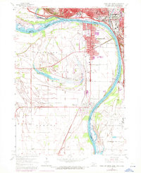
1963 Map of Sioux City South
USGS Topo · Published 1972About this map
The Missouri River and Big Sioux River converge at this tri-state junction, defining a landscape shaped by shifting watercourses and interstate commerce during the early 1960s. The urban centers of Sioux City, Iowa, and South Sioux City, Nebraska, dominate the northern half of the sheet, connected by a network of the Chicago and North Western and Burlington Northern railroads. To the south, the terrain opens into the wide floodplain where Crystal Lake and Millis Beach suggest a history of seasonal recreation near the river bends.
Find a feature on this map
56 named features on this map. Tap any name to fly to it.
Don’t see what you’re looking for? This feature index may not catch every label — zoom into the map to look around manually.
Map Details
Editions of this 1963 Sioux City South Map
4 editions found
Other maps of this area

1898 · Elk Point
USGS Topo · 1:125,000

1901 · Elk Point
USGS Topo · 1:125,000

1907 · Elk Point
USGS Topo · 1:125,000

1955 · Sioux City
USGS Topo · 1:250,000

1958 · Sioux City
USGS Topo · 1:250,000

1959 · Sioux City
USGS Topo · 1:250,000

1963 · Sioux City South
USGS Topo · 1:24,000

1963 · Sioux City North
USGS Topo · 1:24,000

1963 · Jefferson
USGS Topo · 1:24,000

1964 · Sergeant Bluff
USGS Topo · 1:24,000