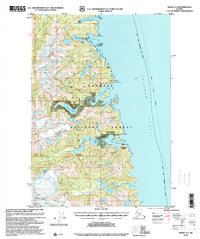
1996 Map of Sitka A-3
USGS Topo · Published 2000About this map
Baranof Island is defined by its dramatic relief and intricate waterway network, where the waters of Chatham Strait meet a coastline of sharp cliffs and deep-water coves. This 1996 revision shows a landscape centered on resource management and isolated outposts, featuring the Fish Hatchery (State) near Hidden Falls and the remote Baranof Lake Cabin (FS). The topography is dominated by alpine peaks such as Mount Furuhelm and Bahovec Peak, with glacially carved basins forming significant water bodies like Takatz Lake 905 and Kasnyku Lake. Settlement is sparse, limited to points like Manleyville and the activity around Warm Springs Bay. These features suggest an era where the Tongass National Forest served as both a protected wilderness and a site for specialized state and federal operations, connected primarily by water routes rather than roads.
Find a feature on this map
44 named features on this map. Tap any name to fly to it.
Don’t see what you’re looking for? This feature index may not catch every label — zoom into the map to look around manually.
Map Details
Editions of this 1996 Sitka A-3 Map
This is the sole edition of this map. No revisions or reprints were ever made.
Other maps of this area

1948 · Sitka B-3
USGS Topo · 1:63,360

1948 · Sitka A-3
USGS Topo · 1:63,360

1948 · Sitka A-2
USGS Topo · 1:63,360

1948 · Sitka B-2
USGS Topo · 1:63,360

1951 · Sitka B-4
USGS Topo · 1:63,360

1951 · Sitka
USGS Topo · 1:250,000

1951 · Port Alexander D-4
USGS Topo · 1:63,360

1951 · Port Alexander D-3
USGS Topo · 1:63,360

1951 · Port Alexander
USGS Topo · 1:250,000

1951 · Port Alexander D-2
USGS Topo · 1:63,360