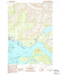
1987 Map of Sitka A-4 SW
USGS Topo · Published 1987About this map
Sitka occupies the southwestern edge of Baranof Island, serving as a focal point for maritime and scientific activity in the late 1980s. The town's coastal presence is anchored by the National Cemetery and the Sitka National Historical Park, while the USGS Magnetic Observatory highlights its importance to geophysical research. The landscape transitions quickly from the busy Eastern Channel and its many small islands like Kutkan Island and Galankin Island to high peaks such as Mount Verstovia and Arrowhead Peak. Water resources dominate the interior, with Blue Lake and Heart Lake feeding into drainage systems like Sawmill Creek, which flows into Sawmill Cove. This survey details the established road network, including Sawmill Creek Road, and captures the intricate coastline where Aleutkina Bay and Silver Bay meet the rugged terrain of the Alexander Archipelago.
Find a feature on this map
60 named features on this map. Tap any name to fly to it.
Don’t see what you’re looking for? This feature index may not catch every label — zoom into the map to look around manually.
Map Details
Editions of this 1987 Sitka A-4 SW Map
This is the sole edition of this map. No revisions or reprints were ever made.
Other maps of this area

1948 · Sitka A-5
USGS Topo · 1:63,360

1951 · Port Alexander D-5
USGS Topo · 1:63,360

1951 · Sitka
USGS Topo · 1:250,000

1951 · Port Alexander D-4
USGS Topo · 1:63,360

1951 · Port Alexander
USGS Topo · 1:250,000

1951 · Sitka A-4
USGS Topo · 1:63,360

1951 · Sitka A-5
USGS Topo · 1:63,360

1952 · Port Alexander
USGS Topo · 1:250,000

1952 · Sitka
USGS Topo · 1:250,000

1954 · Sitka A-4
USGS Topo · 1:63,360