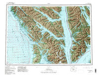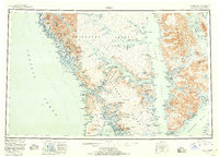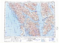
1964 Map of Sitka
USGS Topo · Published 1964About this map
Sitka and the surrounding islands of the Alexander Archipelago are charted here in a period when maritime access defined the region's connectivity. This 1:250,000 scale survey provides a clear view of Southeast Alaska's complex coastline, from the sheltered waters of Tenakee Inlet to the exposed reaches of the Pacific Ocean. Settlements such as Angoon, Pelican, and Chichagof are shown alongside smaller locations like Baranof and Sunnyside, illustrating the scattered nature of human habitation among the fjords and mountains.
Find a feature on this map
40 named features on this map. Tap any name to fly to it.
Don’t see what you’re looking for? This feature index may not catch every label — zoom into the map to look around manually.
Map Details
Editions of this 1964 Sitka Map
This is the sole edition of this map. No revisions or reprints were ever made.