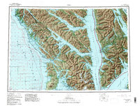
1951 Map of Sitka
USGS Topo · Published 1988About this map
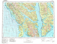
Sitka and the surrounding Alexander Archipelago are documented here during a period of mid-century growth and conservation efforts. The map highlights the coastal settlement patterns of Chichagof Island, Baranof Island, and Admiralty Island, showing the vital maritime connections through Peril Strait and Chatham Strait. Evidence of the region's industrial and military history is visible through the location of the Gypsum site on the northern coast and an Army Camp near the entrance to Sitka Sound. The landscape is dominated by the prominent volcanic cone of Mt Edgecumbe on Kruzof Island, serving as a primary navigational landmark for the region. Significant portions of the territory are designated within the Tongass National Forest and the Admiralty Island National Monument Wilderness, reflecting the early management of these expansive coastal ecosystems. Smaller outposts like Tenakee Springs, Angoon, and the remote Pelican illustrate the dispersed nature of life along the intricate network of inlets and bays.
Find a feature on this map
54 named features on this map. Tap any name to fly to it.
Don’t see what you’re looking for? This feature index may not catch every label — zoom into the map to look around manually.
Map Details
Editions of this 1951 Sitka Map
6 editions found

Other maps of this area

1948 · Juneau A-3
USGS Topo · 1:63,360

1948 · Sitka B-3
USGS Topo · 1:63,360

1948 · Juneau A-4
USGS Topo · 1:63,360

1948 · Sitka D-1
USGS Topo · 1:63,360

1948 · Sitka B-1
USGS Topo · 1:63,360

1948 · Sitka A-5
USGS Topo · 1:63,360

1948 · Sitka A-3
USGS Topo · 1:63,360

1948 · Sitka C-7
USGS Topo · 1:63,360

1948 · Sitka C-2
USGS Topo · 1:63,360

1948 · Sitka A-2
USGS Topo · 1:63,360