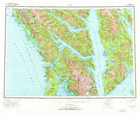
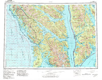
1951 Map of Sitka
USGS Topo · Published 1972About this map
The coastal archipelago of Southeast Alaska, encompassing Chichagof Island, Baranof Island, and Admiralty Island, is mapped here at a pivotal time of mid-century development. The city of Sitka serves as a focal point, flanked by the historical site of Old Sitka and the prominent volcanic cone of Mount Edgecumbe. This survey highlights a landscape defined by its maritime connections, showing numerous coastal settlements like Tenakee Springs, Angoon, and Pelican that relied on the intricate waterways of Chatham Strait and Peril Strait for commerce and travel.
Find a feature on this map
86 named features on this map. Tap any name to fly to it.
Don’t see what you’re looking for? This feature index may not catch every label — zoom into the map to look around manually.
Map Details
Editions of this 1951 Sitka Map
6 editions found

Other maps of this area

1948 · Juneau A-3
USGS Topo · 1:63,360

1948 · Sitka B-3
USGS Topo · 1:63,360

1948 · Juneau A-4
USGS Topo · 1:63,360

1948 · Sitka D-1
USGS Topo · 1:63,360

1948 · Sitka B-1
USGS Topo · 1:63,360

1948 · Sitka A-5
USGS Topo · 1:63,360

1948 · Sitka A-3
USGS Topo · 1:63,360

1948 · Sitka C-7
USGS Topo · 1:63,360

1948 · Sitka C-2
USGS Topo · 1:63,360

1948 · Sitka A-2
USGS Topo · 1:63,360