1948 Map of Juneau A-4
USGS Topo · Published 1956About this map
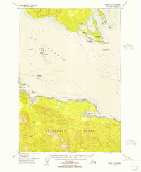
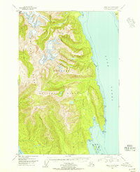
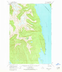
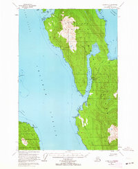
Icy Strait and Lynn Canal meet at this maritime crossroads in the late 1940s, providing a look at the coastal navigation and sparse settlement patterns of the Alaska Panhandle. On Chichagof Island, the terrain rises steeply from Spasski Bay and Whitestone Harbor, where Cabins and a lone Cem suggest isolated outposts or seasonal encampments. The hydrography, compiled from earlier charts, reveals the maritime hazards of the era, including No Use Ledge, Sisters Reef, and Sharp Ledge. These features were critical for vessels navigating the passage between Couverden Island and the archipelago known as The Sisters. The presence of a Light at Swanson Harbor underscores the importance of this sheltered inlet as a refuge for mariners traveling through the Tongass National Forest.
Find a feature on this map
25 named features on this map. Tap any name to fly to it.
Don’t see what you’re looking for? This feature index may not catch every label — zoom into the map to look around manually.
Map Details
Editions of this 1948 Juneau A-4 Map
4 editions found

Other maps of this area
1947 · Juneau B-3
USGS Topo · 1:63,360
1948 · Juneau B-4
USGS Topo · 1:63,360

1948 · Juneau A-3
USGS Topo · 1:63,360

1948 · Juneau B-5
USGS Topo · 1:63,360

1948 · Sitka D-5
USGS Topo · 1:63,360

1948 · Sitka D-3
USGS Topo · 1:63,360

1948 · Sitka D-4
USGS Topo · 1:63,360

1949 · Juneau B-3
USGS Topo · 1:62,500
1949 · Juneau B-4
USGS Topo · 1:63,360
1950 · Juneau A-3
USGS Topo · 1:63,360