
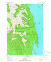
1948 Map of Juneau B-4
USGS Topo · Published 1956About this map
The Chilkat Range dominates this coastal survey, where steep mountain ridges meet the glacial waters of the Lynn Canal. This 1948 aerial photography capture provides a technical record of the Tongass National Forest before widespread modern development, focusing on the intricate shoreline of the Alaska Panhandle. The map documents the transition from high-elevation peaks to the marine environment of the Icy Strait and the small island groups like the Lynn Sisters and Lincoln Island. Geographers and researchers can observe the natural landforms of the region, including the significant Tidal Flat areas and coastal landmarks such as Pt Howard. The absence of developed roads or towns emphasizes the wilderness state of the First Judicial Division during the mid-twentieth century.
Find a feature on this map
8 named features on this map. Tap any name to fly to it.
Don’t see what you’re looking for? This feature index may not catch every label — zoom into the map to look around manually.
Map Details
Editions of this 1948 Juneau B-4 Map
2 editions found
Other maps of this area

1947 · Juneau B-3
USGS Topo · 1:63,360

1948 · Juneau C-5
USGS Topo · 1:63,360

1948 · Juneau A-3
USGS Topo · 1:63,360

1948 · Juneau C-4
USGS Topo · 1:63,360

1948 · Juneau A-4
USGS Topo · 1:63,360

1948 · Juneau B-5
USGS Topo · 1:63,360

1949 · Juneau B-3
USGS Topo · 1:62,500

1949 · Juneau C-4
USGS Topo · 1:63,360

1949 · Juneau B-4
USGS Topo · 1:63,360

1950 · Juneau A-3
USGS Topo · 1:63,360