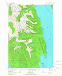
1948 Map of Juneau B-4
USGS Topo · Published 1966About this map
The Chilkat Range dominates this late-1940s landscape, illustrating a wilderness area defined by sharp elevation changes and glacial geography. Positioned within the Tongass National Forest, the topography transitions from the high peaks of the interior down to the intricate coastline along Lynn Canal. This 1948 survey, revised in 1966, shows the maritime significance of the region, where Lincoln Island sits at the northern end of the passage and several Tidal Flat areas emerge along the shore. The map serves as a record of the early Greater Juneau Borough Bdy and provides a clear picture of the natural landmarks used for navigation in Southeast Alaska, such as Pt Howard and the Lynn Sisters at the confluence with Icy Strait.
Find a feature on this map
9 named features on this map. Tap any name to fly to it.
Don’t see what you’re looking for? This feature index may not catch every label — zoom into the map to look around manually.
Map Details
Editions of this 1948 Juneau B-4 Map
2 editions found
Other maps of this area

1947 · Juneau B-3
USGS Topo · 1:63,360

1948 · Juneau C-5
USGS Topo · 1:63,360

1948 · Juneau B-4
USGS Topo · 1:63,360

1948 · Juneau A-3
USGS Topo · 1:63,360

1948 · Juneau C-4
USGS Topo · 1:63,360

1948 · Juneau A-4
USGS Topo · 1:63,360

1948 · Juneau B-5
USGS Topo · 1:63,360

1949 · Juneau B-3
USGS Topo · 1:62,500

1949 · Juneau C-4
USGS Topo · 1:63,360

1949 · Juneau B-4
USGS Topo · 1:63,360