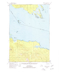
1948 Map of Juneau A-4
USGS Topo · Published 1977About this map
Chichagof Island and the confluence of Icy Strait and Lynn Canal define this maritime landscape at the end of the 1940s. The coastline is marked by small outposts of activity, including isolated cabins and a cemetery on the northern shoreline, likely serving local fishing or trapping operations within the Tongass National Forest. Navigational landmarks such as The Sisters and Entrance Island guide traffic through the deep waters of Swanson Harbor, while the interior of the island is dominated by the steep slopes of Elephant Mountain. The drainage patterns of Spasski and Suntaheen Creek illustrate a wilderness where land lines remained unsurveyed and unmarked at the time of the original survey. This map preserves the primitive infrastructure of the Alexander Archipelago before modern development, noting small lights and specific ledges like No Use Ledge that were critical to the coastal economy.
Find a feature on this map
28 named features on this map. Tap any name to fly to it.
Don’t see what you’re looking for? This feature index may not catch every label — zoom into the map to look around manually.
Map Details
Editions of this 1948 Juneau A-4 Map
4 editions found
Other maps of this area

1947 · Juneau B-3
USGS Topo · 1:63,360

1948 · Juneau B-4
USGS Topo · 1:63,360

1948 · Juneau A-3
USGS Topo · 1:63,360

1948 · Juneau A-4
USGS Topo · 1:63,360

1948 · Juneau B-5
USGS Topo · 1:63,360

1948 · Sitka D-5
USGS Topo · 1:63,360

1948 · Sitka D-3
USGS Topo · 1:63,360

1948 · Sitka D-4
USGS Topo · 1:63,360

1949 · Juneau B-3
USGS Topo · 1:62,500

1949 · Juneau B-4
USGS Topo · 1:63,360