1948 Map of Juneau A-4
USGS Topo · Published 1971About this map
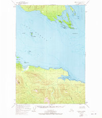
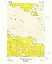
Chichagof Island dominates the southern half of this 1948 survey, where the convergence of Icy Strait and the Lynn Canal defines the maritime landscape. The northern shore of the island is marked by Whitestone Harbor and the drainage of Spasski Creek, while a small Cem and isolated Cabins suggest the limited but present human activity within the Tongass National Forest. To the north, the mainland peninsula terminates at Pt Couverden, protected by a cluster of coastal features including Swanson Harbor and Ansley Island. The central waterway is punctuated by navigational landmarks such as The Sisters and Rocky Island, illustrating the coastal transit patterns before the mid-century. The topography rises sharply from the shoreline to the peak of Elephant Mountain, showcasing the steep elevation changes characteristic of the Alexander Archipelago.
Find a feature on this map
29 named features on this map. Tap any name to fly to it.
Don’t see what you’re looking for? This feature index may not catch every label — zoom into the map to look around manually.
Map Details
Editions of this 1948 Juneau A-4 Map
4 editions found

Other maps of this area
1947 · Juneau B-3
USGS Topo · 1:63,360
1948 · Juneau B-4
USGS Topo · 1:63,360

1948 · Juneau A-3
USGS Topo · 1:63,360
1948 · Juneau A-4
USGS Topo · 1:63,360

1948 · Juneau B-5
USGS Topo · 1:63,360

1948 · Sitka D-5
USGS Topo · 1:63,360

1948 · Sitka D-3
USGS Topo · 1:63,360

1948 · Sitka D-4
USGS Topo · 1:63,360

1949 · Juneau B-3
USGS Topo · 1:62,500
1949 · Juneau B-4
USGS Topo · 1:63,360