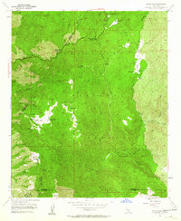
1954 Map of Sitton Peak
USGS Topo · Published 1961About this map
Santa Ana Mountains peaks and deep drainage basins define this 1954 survey, which reveals a landscape of high-country ranching and early mountain recreation. Private holdings like Stewart Ranch and Wheeler Ranch are situated near expansive meadows known as potreros, including Verdugo Potrero and Belardes Potrero. The era's increasing accessibility is evident along the winding Ortega Highway, providing access to the Upper San Juan Campground and Lower San Juan Campground within the Cleveland National Forest. The map also captures the northern fringes of Camp Joseph H Pendleton, marking the intersection of federal forest land, military training grounds, and the historic Potrero El Cariso Land Grant. Significant water sources like Serrano Spr and Quail Spring dot the terrain near Sitton Peak, illustrating the critical reliance on springs in this arid high-altitude environment.
Find a feature on this map
42 named features on this map. Tap any name to fly to it.
Don’t see what you’re looking for? This feature index may not catch every label — zoom into the map to look around manually.
Map Details
Editions of this 1954 Sitton Peak Map
4 editions found
Other maps of this area

1901 · Southern California Sheet No. 1
USGS Topo · 1:250,000

1901 · Elsinore
USGS Topo · 1:125,000

1901 · San Luis Rey
USGS Topo · 1:125,000

1902 · Capistrano
USGS Topo · 1:125,000

1902 · Corona
USGS Topo · 1:125,000

1904 · Southern California Sheet No. 2
USGS Topo · 1:250,000

1904 · Southern California Sheet No. 1
USGS Topo · 1:250,000

1906 · Capistrano
USGS Topo · 1:125,000

1941 · Margarita Peak
USGS Topo · 1:62,500

1942 · Lake Elsinore
USGS Topo · 1:62,500
Featured Places
- Marine Corps Base Camp Pendleton, CA
- San Diego County, CA
- Orange County, CA
- Riverside County, CA
- United States