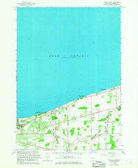
1965 Map of Sixmile Creek
USGS Topo · Published 1968About this map
Lake Ontario defines the northern edge of this Niagara County landscape, where the shoreline is punctuated by small summer communities and recreational spots like Uneeda Beach, Hopkins Beach, and Harrison Grove. Moving inland from the lake, the terrain transitions into a productive agricultural and residential interior divided by the border between Porter and Wilson. This area is knit together by a dense network of country roads including Youngstown Road and Dickersonville Road, which crisscross the wandering paths of Sixmile Creek and Twelvemile Creek.
Find a feature on this map
27 named features on this map. Tap any name to fly to it.
Don’t see what you’re looking for? This feature index may not catch every label — zoom into the map to look around manually.
Map Details
Editions of this 1965 Sixmile Creek Map
This is the sole edition of this map. No revisions or reprints were ever made.
Other maps of this area

1894 · Niagara Falls
USGS Topo · 1:62,500

1894 · Wilson
USGS Topo · 1:62,500

1896 · Niagara Falls
USGS Topo · 1:62,500

1897 · Tonawanda
USGS Topo · 1:62,500

1899 · Niagara
USGS Topo · 1:125,000

1900 · Wilson
USGS Topo · 1:62,500

1900 · Tonawanda
USGS Topo · 1:62,500

1900 · Niagara Falls
USGS Topo · 1:62,500

1901 · Niagara Falls
USGS Topo · 1:62,500

1901 · Tonawanda
USGS Topo · 1:62,500