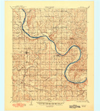
1931 Map of Skedee
USGS Topo · Published 1949About this map
The Arkansas River carves a winding path across this landscape, serving as the primary boundary between Fairfax and Blackburn. During the late 1920s, this region was characterized by small-scale farming and river-dependent transportation, evidenced by the East Bend Ferry and numerous named crossings like Sorghum Ford. The rail network of the Atchison Topeka and Santa Fe and St Louis-San Francisco railroads connected small communities like Skedee and Maramec to broader markets.
Find a feature on this map
56 named features on this map. Tap any name to fly to it.
Don’t see what you’re looking for? This feature index may not catch every label — zoom into the map to look around manually.
Map Details
Editions of this 1931 Skedee Map
3 editions found
Other maps of this area

1909 · Pawhuska
USGS Topo · 1:125,000

1910 · Pawhuska
USGS Topo · 1:125,000

1912 · Hominy
USGS Topo · 1:125,000

1915 · Hominy
USGS Topo · 1:125,000

1915 · Hominy
USGS Topo · 1:62,500

1929 · Yale
USGS Topo · 1:62,500

1929 · Ripley
USGS Topo · 1:62,500

1929 · Skedee
USGS Topo · 1:62,500

1930 · Pawnee
USGS Topo · 1:62,500

1931 · Skedee
USGS Topo · 1:62,500