
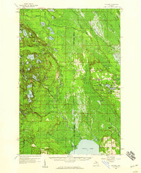
1931 Map of Skeels Lake NE
USGS Topo · Published 1931About this map
The Hiawatha National Forest dominates this 1931 survey of the Michigan Upper Peninsula, revealing a complex landscape of glacial lakes and wetlands. The intricate shoreline of Skeels Lake and the serpentine path of the Indian River highlight a region where water routes were essential for timber and early recreation. This area, spanning the Alger and Schoolcraft county lines, shows the wilderness before modern road development was fully realized. Significant landmarks for local history include Hill Tower and several large water bodies like McKeaver Lake and Petes Lake. The map serves as a vital record of this backcountry during the early years of the National Forest's management, documenting named lakes such as Straits Lake and Grassy Lake that remain central to the region's geography.
Find a feature on this map
65 named features on this map. Tap any name to fly to it.
Don’t see what you’re looking for? This feature index may not catch every label — zoom into the map to look around manually.
Map Details
Editions of this 1931 Skeels Lake NE Map
This is the sole edition of this map. No revisions or reprints were ever made.
Other maps of this area

1931 · Steuben SW
USGS Topo · 1:31,680

1931 · Shingleton SW
USGS Topo · 1:31,680

1931 · Steuben NW
USGS Topo · 1:31,680

1931 · Munising SE
USGS Topo · 1:31,680

1932 · Skeels Lake SE
USGS Topo · 1:31,680

1932 · Skeels Lake NW and SW
USGS Topo · 1:31,680

1958 · Corner Lake
USGS Topo · 1:62,500

1958 · Munising
USGS Topo · 1:62,500

1958 · Shingleton
USGS Topo · 1:62,500
1958 · Steuben
USGS Topo · 1:62,500