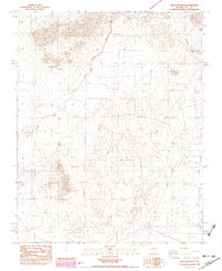
1984 Map of Skeleton Hills
USGS Topo · Published 1984About this map
Skeleton Hills and the rugged northern reaches of the Amargosa Desert define this desert landscape in southern Nye County. The terrain is marked by the dry drainage of Rock Valley Wash and the steep slopes of the Specter Range to the northeast. Human presence is evidenced primarily by industrial and extractive markers, including a network of Prospects and a legacy Railroad Grade cutting across the northeastern corner. Revisions from 1982 aerial photography, shown in purple, highlight a Double Wood Pole Transmission Line and updated desert tracks, reflecting late 20th-century utility and access development in this arid environment.
Find a feature on this map
9 named features on this map. Tap any name to fly to it.
Don’t see what you’re looking for? This feature index may not catch every label — zoom into the map to look around manually.
Map Details
Editions of this 1984 Skeleton Hills Map
2 editions found
Other maps of this area

1908 · Furnace Creek
USGS Topo · 1:250,000

1910 · Furnace Creek
USGS Topo · 1:250,000

1942 · Skull Mountain
USGS Topo · 1:125,000

1948 · Death Valley
USGS Topo · 1:250,000

1952 · Ash Meadows
USGS Topo · 1:62,500

1952 · Specter Range
USGS Topo · 1:62,500

1954 · Death Valley
USGS Topo · 1:250,000

1956 · Death Valley
USGS Topo · 1:250,000

1957 · Death Valley
USGS Topo · 1:250,000

1958 · Death Valley
USGS Topo · 1:250,000