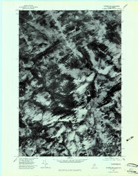
1978 Map of Skinner NE
USGS Topo · Published 1983About this map
Sixtynine Mountain dominates the central landscape of this Somerset County borderland, where the Maine wilderness meets the Quebec frontier. This 1978 orthophotoquad, derived from high-altitude aerial photography, provides a literal visual record of the forest management and drainage patterns in the upper reaches of the Riviere Du Loup watershed. The imagery reveals the stark textures of timber harvesting and regrowth, contrasting the deep shadows of the ridges with the bright, cleared slopes near Bellarmin. Hydrological features like Etang Du Loup and the winding courses of the East Branch Gulf Stream and West Branch Gulf Stream illustrate the natural flow of water through this heavily wooded upland. This document is particularly valuable for tracing historical land use and forest cover before decades of subsequent industrial timber activity altered the terrain.
Find a feature on this map
6 named features on this map. Tap any name to fly to it.
Don’t see what you’re looking for? This feature index may not catch every label — zoom into the map to look around manually.
Map Details
Editions of this 1978 Skinner NE Map
This is the sole edition of this map. No revisions or reprints were ever made.
Other maps of this area

1923 · Attean
USGS Topo · 1:62,500

1925 · Attean
USGS Topo · 1:62,500

1927 · Sandy Bay
USGS Topo · 1:48,000

1928 · Skinner
USGS Topo · 1:48,000

1930 · Sandy Bay
USGS Topo · 1:62,500

1931 · Skinner
USGS Topo · 1:62,500

1944 · Sandy Bay
USGS Topo · 1:62,500

1949 · Jackman
USGS Topo · 1:250,000

1950 · Attean
USGS Topo · 1:50,000

1963 · Jackman
USGS Topo · 1:250,000