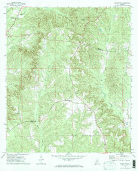
1971 Map of Skinnerton
USGS Topo · Published 1974About this map
Murder Creek and the West Sepulga River define the undulating landscape of south Alabama in this early 1970s survey. The map details a rural geography split by the Monroe Co / Conecuh Co line, where the small settlement of Skinnerton serves as a local crossroads. High ground near the county boundary is marked by the McWilliams Lookout Tower, reflecting the importance of forestry in this region.
Find a feature on this map
17 named features on this map. Tap any name to fly to it.
Don’t see what you’re looking for? This feature index may not catch every label — zoom into the map to look around manually.
Map Details
Editions of this 1971 Skinnerton Map
2 editions found
Other maps of this area

1953 · Andalusia
USGS Topo · 1:250,000

1957 · Andalusia
USGS Topo · 1:250,000

1967 · Beatrice
USGS Topo · 1:24,000

1971 · Lyeffion
USGS Topo · 1:24,000

1971 · Skinnerton
USGS Topo · 1:24,000

1971 · China
USGS Topo · 1:24,000

1971 · Burnt Corn
USGS Topo · 1:24,000

1971 · Bethel
USGS Topo · 1:24,000

1971 · Beatrice
USGS Topo · 1:24,000
1981 · Nadawah
USGS Topo · 1:24,000