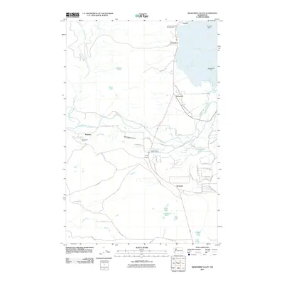
2011 Map of Skokomish Valley
USGS Topo · Published 2011About this map
Annas Bay and the tidal Skokomish Flats define the landscape where the Skokomish River meets the saltwater at The Great Bend. This 2011 survey documents a mix of tribal lands and rural development, with Skokomish serving as a central hub near N Reservation Rd and N Tribal Center Rd. The importance of the local fishery is evident through the presence of the George Adams Salmon Hatchery and the Shelton Trout Hatchery, highlighting the intersection of industrial aquaculture and the natural river system. To the south, the settlement of Brockdale sits along E Brockdale Rd, while the northern shoreline is dominated by Potlatch State Park Campground and the community of Potlatch. The map captures a detailed view of the Skokomish Valley, from its narrow origins at Purdy Canyon to the broad estuaries along the coast.
Find a feature on this map
62 named features on this map. Tap any name to fly to it.
Don’t see what you’re looking for? This feature index may not catch every label — zoom into the map to look around manually.
Map Details
Editions of this 2011 Skokomish Valley Map
This is the sole edition of this map. No revisions or reprints were ever made.
Other maps of this area

1939 · Shelton
USGS Topo · 1:62,500

1943 · Potlatch
USGS Topo · 1:62,500

1943 · Nahwatzel Lake
USGS Topo · 1:62,500

1952 · Potlatch
USGS Topo · 1:62,500

1953 · Mt Tebo
USGS Topo · 1:62,500

1953 · Shelton
USGS Topo · 1:62,500

1953 · Elma
USGS Topo · 1:62,500

1958 · Seattle
USGS Topo · 1:250,000

1962 · Seattle
USGS Topo · 1:250,000
1981 · Nahwatzel Lake
USGS Topo · 1:24,000