
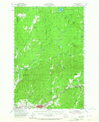
1953 Map of Elma
USGS Topo · Published 1956About this map
The Satsop River and its multiple forks dominate this mid-century view of the borderlands between Grays Harbor and Mason Counties. In the early 1950s, the landscape was a complex mosaic of industrial timber operations and small rural outposts. The network of the Northern Pacific railroad and numerous logging routes, such as the Bingham Creek Truck Trail and the Dayton Truck Trail, illustrate the heavy reliance on timber extraction. Notable settlements like Elma and McCleary serve as the primary hubs, while smaller locales like Deckerville, Frisken Wye, and Sine appear alongside rural community centers like the Mary M Knight School and Cloquallum Grange. The presence of several distinct prairies, including Carstairs Prairie and Goose Prairie, suggests a varied topography where open grasslands met the dense reaches of the Capitol State Forest. Leisure and conservation are also evident at Schafer State Park and the Oaks Ridge Golf Course.
Find a feature on this map
72 named features on this map. Tap any name to fly to it.
Don’t see what you’re looking for? This feature index may not catch every label — zoom into the map to look around manually.
Map Details
Editions of this 1953 Elma Map
2 editions found
Other maps of this area

1921 · Satsop
USGS Topo · 1:62,500

1939 · Shelton
USGS Topo · 1:62,500

1940 · Montesano
USGS Topo · 1:62,500

1941 · Mobray
USGS Topo · 1:62,500

1941 · Gate
USGS Topo · 1:62,500

1941 · Ford
USGS Topo · 1:62,500

1943 · Potlatch
USGS Topo · 1:62,500

1943 · Nahwatzel Lake
USGS Topo · 1:62,500

1943 · Mobray
USGS Topo · 1:62,500

1952 · Potlatch
USGS Topo · 1:62,500