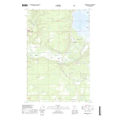
2020 Map of Skokomish Valley
USGS Topo · Published 2020About this map
The Skokomish River flows through the heart of Mason County, shaping the alluvial Skokomish Valley as it approaches its terminus at Hood Canal. This 2020 survey illustrates a complex landscape of tribal lands, private homesteads, and protected woodlands at the edge of the Olympic National Forest. The settlement of Skokomish serves as a focal point near the tidal Skokomish Flats, while smaller communities like Mohrweis are situated further inland along the valley roads. The topography transitions sharply from the flat delta of Annas Bay and The Great Bend to the steep drainages of Purdy Canyon. Numerous small bodies of water, such as Stevens Lake, Kent Lake, and Old Hatchery Lake, dot the glacial terrain, reflecting the region's dense hydrological network. Local transport is defined by a web of rural routes like W Skokomish Valley Rd and N Reservation Rd that link family homes and timber lands.
Find a feature on this map
69 named features on this map. Tap any name to fly to it.
Don’t see what you’re looking for? This feature index may not catch every label — zoom into the map to look around manually.
Map Details
Editions of this 2020 Skokomish Valley Map
This is the sole edition of this map. No revisions or reprints were ever made.
Other maps of this area

1939 · Shelton
USGS Topo · 1:62,500

1943 · Potlatch
USGS Topo · 1:62,500

1943 · Nahwatzel Lake
USGS Topo · 1:62,500

1952 · Potlatch
USGS Topo · 1:62,500

1953 · Mt Tebo
USGS Topo · 1:62,500

1953 · Shelton
USGS Topo · 1:62,500

1953 · Elma
USGS Topo · 1:62,500

1958 · Seattle
USGS Topo · 1:250,000

1962 · Seattle
USGS Topo · 1:250,000
1981 · Nahwatzel Lake
USGS Topo · 1:24,000