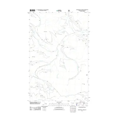
2011 Map of Skookoleel Creek
USGS Topo · Published 2011About this map
Big Creek and its many tributaries define this section of the Flathead National Forest, shown here as it was surveyed in the early 21st century. High-elevation vantage points such as Forks Lookout and Smoky Lookout Tower overlook a landscape carved by Skookoleel Creek and Elelehum Creek. The drainage patterns are intricate, with numerous seasonal and perennial streams like Kletomus Creek and Hallowat Creek feeding into the larger watercourses. Transportation through this terrain is limited to established forestry routes, including Natl Forest Develop Road 1698 Rd and Natl Forest Develop Road 316E Rd, which provide access across Nicola Ridge and toward the base of Big Mountain. This map documents a period of modern forest management and recreational access within the Smoky Range.
Find a feature on this map
20 named features on this map. Tap any name to fly to it.
Don’t see what you’re looking for? This feature index may not catch every label — zoom into the map to look around manually.
Map Details
Editions of this 2011 Skookoleel Creek Map
This is the sole edition of this map. No revisions or reprints were ever made.
Other maps of this area

1906 · Kintla Lakes
USGS Topo · 1:125,000

1938 · Kintla Lakes
USGS Topo · 1:125,000

1943 · Kalispell
USGS Topo · 1:125,000

1957 · Kalispell
USGS Topo · 1:250,000

1960 · Kalispell
USGS Topo · 1:250,000

1961 · Kalispell
USGS Topo · 1:250,000

1962 · Beaver Lake
USGS Topo · 1:24,000
1962 · Whitefish
USGS Topo · 1:24,000
1962 · Columbia Falls North
USGS Topo · 1:24,000
1966 · Demers Ridge
USGS Topo · 1:24,000