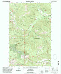
1994 Map of Skookoleel Creek
USGS Topo · Published 1997About this map
Flathead National Forest land defines this mountainous region of Montana, where the elevations of the Whitefish Range and the Smoky Range converge. The topography is dominated by a complex network of drainage basins, with Big Creek and Skookoleel Creek serving as the primary arteries for the area's hydrology. Surveyed primarily from aerial photography in the mid-1960s with updates through the early 1990s, the map reveals the layout of ridges and drainages that have historically dictated movement through the backcountry, such as Nicola Ridge and Hallowat Creek.
Find a feature on this map
20 named features on this map. Tap any name to fly to it.
Don’t see what you’re looking for? This feature index may not catch every label — zoom into the map to look around manually.
Map Details
Editions of this 1994 Skookoleel Creek Map
This is the sole edition of this map. No revisions or reprints were ever made.
Other maps of this area

1906 · Kintla Lakes
USGS Topo · 1:125,000

1938 · Kintla Lakes
USGS Topo · 1:125,000

1943 · Kalispell
USGS Topo · 1:125,000

1957 · Kalispell
USGS Topo · 1:250,000

1960 · Kalispell
USGS Topo · 1:250,000

1961 · Kalispell
USGS Topo · 1:250,000

1962 · Beaver Lake
USGS Topo · 1:24,000
1962 · Whitefish
USGS Topo · 1:24,000
1962 · Columbia Falls North
USGS Topo · 1:24,000
1966 · Demers Ridge
USGS Topo · 1:24,000